
The wind measurement campaign is a critical step in the development of a wind energy project. Accuracy and consistency of measurements are instrumental in the design and optimization of the lay-out as well as in the feasibility analysis and eventually in the financing of a project. Several measuring solutions are implemented by wind resource analysts when it comes to collecting and analyzing wind data. Some of the most mature and widespread measuring techniques are presented in this article.
Met masts
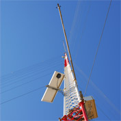
This method consists of running on-site meteorological measurements using a mast of variable size fitted with measuring and data-collection equipment.
Depending on the project size and terrain complexity, several masts can be installed on a given site. The size of the mast should be at least equal to 2/3 of the hub height to reduce uncertainties on vertical wind profile extrapolations. Wind resource analysts assisted by project managers select the most appropriate location to install the equipment.
1. Anemometers
Anemometers are used to measure the wind speed. Depending on the size of the mast, 3 to 5 anemometers are installed at various heights in order to accurately calculate the vertical profile of the wind. Length of booms is set according to IEC 61400 standard.
Each anemometer is calibrated by a specialized institute in compliance with international standards (MEASNET). The calibration is performed before installation of the mast to ensure the quality of the campaign.
Anemometers used for energy predictions consist of three hemispherical cups revolving around a vertical axis. Best-in class sensors are used by FUTUREN for its wind measurement campaigns to avoid inaccuracy and over-speeding effects in the collected data.
2. Wind vanes
Measuring masts are equipped with two wind vanes which measure the wind direction. The vane must be positioned on a horizontal boom as high as possible but at sufficient distance below the top anemometer to avoid shadow effect. The offset of the vane is determined by using the boom orientation, a compass and a map.
3. Other meteorological factors
Humidity, air pressure and temperature influence energy production. Therefore, it is useful to collect these data during the measuring campaign.
Humidity measurements are particularly useful to predict risk of icing and therefore anticipate mitigation measures such as heating blade systems.
Air temperature affects air density and thus directly impacts energy production of the wind farm.
Sensors can be placed on the mast but data can also be collected from neighboring weather stations since these data usually require less accuracy.
4. Data collection equipment
Data produced by the sensors are then stored at regular time intervals in a logger placed in a steal cabinet in the lower section of the mast. Power needs of the electronic equipments are supplied using photovoltaic panels.
The logger is then connected to a telephone line or uses a GSM connection in order to transmit information. After collection, wind resource analysts carefully screen through the data and gaps in the time series are filled in.
Data are then computed into a specific wind calculation software in order to produce the energy assessment of the site.
Remote sensing instruments
A SODAR – which stands for Sonic Detection and Ranging – is a remote sensing instrument used for meteorological measurements.
Atmospheric data are calculated based on the speed of sound. Measurements are performed by sending out an acoustic signal. The return signal is then analyzed to evaluate wind speed, wind direction and atmospheric turbulences.
In a similar way, a LIDAR (Light Detection and Ranging) analyzes the wind profile through a laser signal. On the same principle as for the SODAR, a light beam is sent out in the atmosphere in a three dimensional cone. The Doppler shift of laser radiation backscattered by air particles is measured to define wind characteristics.
SODAR and LIDAR measurements offer the possibility to analyze the wind profile at various altitudes and over the rotor surface which is of interest mostly when the project is designed with large-size rotors and/or big hub heights.
Measuring data are stored in the SODAR/LIDAR and can be collected via email, internet or mobile connection.
Like measuring masts, remote sensing equipments can function as stand-alone applications. If SODAR can operate directly on photovoltaic panels, power requirements of a LIDAR are higher and require power supply from fuel cell or from the grid, making the use of this application more challenging in remote sites.
Measurement campaigns performed with SODAR and LIDAR usually last a few weeks and often complement mast measurements to extrapolate or correlate with existing data.
SODAR and LIDAR measuring techniques find various applications in the development of a project or operation of a wind farm such as power curve assessment, calculation of thermal effects on energy yield, lay-out design, complex site analysis, etc.
Limited encumbrance, quick deployment and the absence of administrative requirements before installation are some of the advantages of remote sensing equipments over traditional wind measurements. In some situations they can also prove to be a cost effective alternative to big size measuring masts.
Although remote sensing solutions are generating increasing interest among wind professionals, mast measurements are still considered mandatory in the development of a project. SODAR and LIDAR measurements are often used in complement of mast measurements and can offer significant benefits by refining existing data and improving the understanding of a wind profile in complex locations of a given site.
Vos réactions et Questions 8